We booked a full week at Big Bend Resort & Adventure, TX in
Terlingua, TX our second private RV campground. Terlingua is a small town situated
close to the Mexican board between Big Bend NP and Big Bend Ranch SP. There are
no RV sites in the state park and the sites in the national park have no electrical
or water hookup.
Big Bend Resort & Adventure has full hookup. Most of the sites have
no or little shade with a gravel basin. The resort has an on-site game room,
pretty fast Wi-Fi, a small store with gas, and laundry. We enjoyed evening
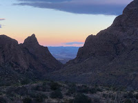
walks around the graveyard, ghost town, and Starlite theater/restaurant. The sunset were spectacular and for about 45 minutes at dusk we were treated to bats flying over and feeding.
We actual booked our time during Texas public school’s spring break. I
think 20-30 years ago this area was very lightly visited that’s not the case
anymore and for-sure during spring break. The main focus for the spring
breakers was definitely Big Bend National Park with only a little spill over
into the state park. Another challenge is that dogs are not allowed on any of
the Big Bend NP trails. However, the Big Bend Ranch SP has a couple of dog
friendly trails with a great trail for mountain biking (one of our favorites of
the trip). One of the keys to making this whole RV adventure work is to be fixable
and adapt to any constrains. To avoid the crowds and hottest part of the day,
we do most all of our activities before lunch. For some of the most popular
hikes in BBNP, we would leave the campsite, so we could start the hike before sunrise.
As the temps were raising during the day, we alternated hikes so one of us
could hang with Pippy.
Hiking in Big Bend National Park
Entering the park for the first time.... wow, lovely desert sunrise
Santa Elena Canyon is a 1.3 mile (one way) moderately trafficked out and back trail located near Terlingua, Texas. After crossing Terlingua Creek, the trail ascends on paved steps to a vista, then descends back to the water's edge, continuing into the canyon until the canyon walls meet the water. A Big Bend classic. Trail is impassable when Terlingua Creek floods.

Mule Ear Peak (to the Springs) This hike leads through the foothills of the Chisos Mountains, skirts Trap Mountain, and crosses several arroyos. Near the spring is an old rock corral. The spring itself is overgrown with shrubs, but ferns and cattails also grow there. Remember, no contaminating/bathing in backcountry springs.


Lost Mine Trail (4.8 miles round trip, begin at mile 5.1 on the Basin Road): The Lost Mine Trail is perhaps the best hike to undertake if you only have a day to spend in Big Bend. It's not terribly long, provides an interpretive guide to the plants, animals and geological formations seen in Big Bend and it's not too far from the main park ranger station or the Chisos Basin Lodge rooms. The Lost Mine Trail is by no means a trivial hike. You'll cover almost 5 miles and climb over 1,000 feet. The hike starts off at the waypoint "Trailhead" and gains altitude immediately.

 |
| Above my attempt at an iPhone Pan photo. |


 |
| StarBady |
Sunday, March 18th was last day before packing up and heading to the Fort Davis area about 110 miles north. We figured the spring breakers would be headed home, so we decided on one last hike in Big Bend around the Chisos Basin where the visitor center and Chisos Mountains Lodge are located. Before Sunday, getting a parking spot was basically unattainable without a 2-3 hour wait.
The Windows (5.6 miles round trip, we opted to hike about half of the hike): Begin at the Chisos Basin Trailhead, this trail descends through Oak Creek Canyon to the Window pour-off which frames panoramic desert vistas.
A nice hike but we decided to cut it short and try a more remote hike that involved about 6 mile drive on Grapevine Hills Road (nice to have a 4x4). Ended up being such a great hike to end this portion of the stay.
Grapevine Hills Trail (2.2 miles round trip): This trail leads to a group of balanced rocks in the heart of the Grapevine Hills. Initially, the trail follows a gravel wash, then climbs steeply for the last quarter mile into the boulders. Grapevine Hills is an exposed laccolith, with many giant, rounded boulders that are tempting to climb, but watch for snakes.
Hiking and Mountain Biking in Big Bend Ranch State Park
Rancherias Loop (couple of miles out and back) It begins at the East Rancherias Trailhead and ends at the West Rancherias Trailhead. It ascends from lower elevations near the Rio Grande through the rugged canyons of the Bofecillos Mountains. Natural springs with fairly reliable water, riparian habitats and historicalperiod ruins will be encountered along the way.

A nice stop at Fort Leaton State Historic Site on the west end of Big Bend Ranch close to the town of Presidio, TX, Stopped in the site where they suggested that might want to eat lunch at "The Bean Cafe" near by.


Hoodoos Trail (1.1 miles, dog friendly) This site is named for its unique geological features called “hoodoos.” The word hoodoo originated in Africa and refers to what they believed were strange animal shapes in the rocks and embodied evil spirits. A short trail leads you to a series of hoodoos, along the bank of the Rio Grande. Another great hike for a family with children. Leashed dogs are allowed on this trail.


Hoodoos Trail (1.1 miles, dog friendly) This site is named for its unique geological features called “hoodoos.” The word hoodoo originated in Africa and refers to what they believed were strange animal shapes in the rocks and embodied evil spirits. A short trail leads you to a series of hoodoos, along the bank of the Rio Grande. Another great hike for a family with children. Leashed dogs are allowed on this trail.


Closed Canyon (1.4 miles round trip or more) This is a short hike into a narrow slot canyon. The high walls of the canyon guide you along the way, progressively becoming narrower as the canyon trends towards the river. Because the canyon walls are so tall and narrow, little sunlight reaches the floor and the temperature in the canyon is substantially cooler than out in the exposed desert for most of the day. A great retreat from the summer heat and a perfect hike for a family. Leashed dogs are allowed on this trail.


Mountain biking on the Contrabando Multi-use Trails: The East and West Contrabando Trailheads are the two main access points to this system. It is made of up of over 25 miles of interconnected trails of varying difficulty that expose you to some spectacular natural and cultural landscapes in the park. We road from the West Trailhead parking area. I road a portion of the West Main Trail to Waterhole Trail making about 7.5 miles out-and-back. Mickie road the Fresno Divide trail to the Dome trail, and back on the West Main Trail making a much longer loop. Great trail system for Mtn Biking!


Based in the Terlingua, TX, we made reservation to attend a Star Party at the McDonald Observatory in the Davis Mountains for Saturday, March 17th. This would be a drive of around 120 miles one-way. Our plan was to drive from Terlingua to Carlsbad, NM on Monday, so either location wasn't very close to the Observatory. But, we decided on out way, we would stop in Marfa. There is just a lot of crazy stuff to do around there.
As Saturday was approaching, we decided to make our first change in reservations. Everyone, we were talking to around the Big Bend area had such great things to say about the Fort Davis area. We were able to cancel reservations at Brantley Lake State Park, NM and book the same time at Davis Mountain State Park. We still did our crazy Saturday driveathon with changing our Star Party reservation for the following Tuesday (now just a short drive from Davis Mountain SP).
Scenes around Marfa (famous for the filming of Giant)


Food Shark

The Hotel Paisano


Ok, I really like the movie Giant, but I think the quintessential west Texas movie is "The Last Picture Show". Now a short drive to Prada Marfa store......


Next stop Fort Davis, TX


